A selection of specific routes through which you will discover a large part of the hidden secrets and archaeological treasures of Crete, its nature, its long lasting history full of myths and legends and the soul of its inhabitants is proposed as follows from the West to the East:
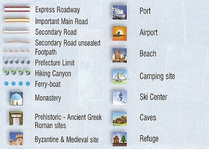
-MAP SYMBOLS EXPLANATION:
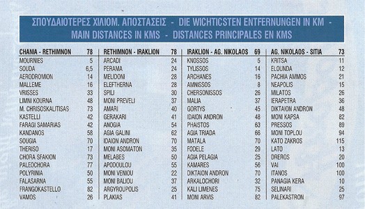
-MAIN DISTANCES in CRETE:
CHANIA COUNTY/PREFECTURE DRIVING ROUTES:
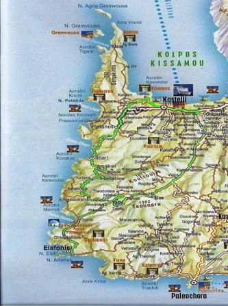
KASTELLI (KISSAMOS) – ELOS – ELAFONISSI -SouthWest outermost point of Crete- (appx. 90 km)
Highlights: Kastelli Kissamos Venetian fortress (Castelo) and its very interesting Archaeological Museum (also a boat trip to the island of Gramvousa & Balos is operated from its Port). Topolia Village with homonym gorge, chestnut villages along the scenic mountainous valley, Milia old restored eco-friendly traditional Village, Elos Village Chestnut Festival held in October. Monastery Chrisoskalitissas (the tradition says that there is a golden step in the staircase ascending to the monastery but the sinners can’t see it) situated on a rocky peak with a panoramic view. Elafonissi is a small low islet that is essentially the extension of the land given that the depth of the sea in the strait the separates it from this is 2-3 feet, fact that allows the access to the island on foot. It is the southwest outermost point of Crete and one of the most impressive landscapes with particular natural beauty of the island and a very interesting ecosystem as the dunes that cover the most of the island are combined with beautiful beaches. In its western rocky elevated part –where there is a lighthouse and the mass grave of shipwrecked of the Austrian “Imperatrice” that foundered in 1907- is presumed that was also sanctuary of Apollo. East of Elafonissi is developed one of the few forests of cedars of Crete.
In our return to Kastelli, in the region of the village Kefali we may follow the road to the west direction. We continue north, leaving behind us the small fishing village Sfinari and from the village Platanos we can visit Falasarna to enjoy the spectacular sunset in one of the most beautiful beaches of Crete.
KOLYMBARI – VOUKOLIES – KANDANOS – PALEOCHORA (appx 70 km)
Highlights: Kolymbari is a picturesque coastal village where the Monastery of Odigitria Gonia -founded in 1618 - with a remarkable collection of post-Byzantine icons and other religious relics is. From Kolimbari you can visit by boat to the peninsula Rodopou and see the ruins of the ancient city Dyktina and the temple of the goddess Artemis, which dates back to 2nd century BC.
From the settlement Tavronitis we follow the road south along the course of its river. We cross the green and rural landscape and after the village Voukolies -a large village with an important Saturday morning market- we begin to climb in the hilly landscape to the Historical village Kandanos- rich in Byzantine churches of recording 13 to 14 century, wonderful history and monuments of the battles with the Nazis in 1941 and Canyon Kandanos with the stone path suitable for walking and/or cycling -.
Paleochora built on the ruins of ancient Dorrian city Kalamidi is one of the most beautiful little towns of Crete with unique beaches stretching 20 km in the shade of rocks and cedars of the area. It also offers hiking and trips with small boats that connect Paleochora to Sougia, Agia Roumeli, Loutro, Elafonissi, Sfakia and Gavdos island. Kountouras, located just west of Paleochora, with the unique beauty cedars is a coastal area of particular natural and ecological interest that may worth a visit.
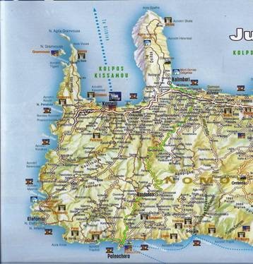
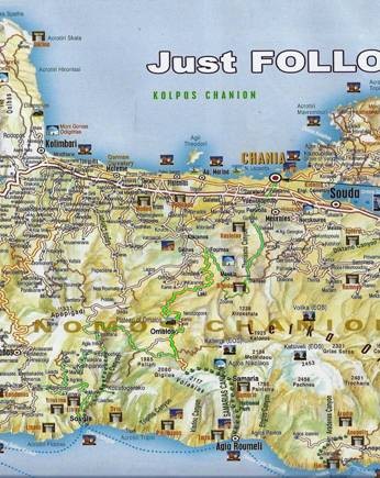
CHANIA – THERISSO – LAKKOI – OMALOS (appx. 95 km)
Highlights: Therisso village, with its dramatic mountain scenery and gorge, sits at 580m in the massive Lefka Ori or White Mountain range encircled by rounded mountains whose naked tops contrast sharply with the dense vegetation of the place. It has a remarkable history, intrinsically interwoven with the freedom of the Cretan people and the Union of Crete with Greece. The road from Chania winds through the 6 km long and impressive Theriso Gorge, and in several places you drive between vertical cliffs surrounded by the greenery of chestnuts and oaks which at times actually project over the road. The gorge is partially formed by the tree-lined river Kladissos. Lakkoi village is located at an altitude of 500 meters. It has great history and was the field of many battles of the revolution against the Turks. Worth a stop at traditional cafes or a restaurant as all have stunning views of the White Mountains and the wildlife. Most of the villagers are shepherds. Omalos (1080 meters altitude) one of the biggest plateaus of Crete has shape of irregular circle with an area of appx 25 sq km and is surrounded by many imposing peaks and the principal are Gigilo (2005m) and Volakia (2117m). Throughout the area there are abandoned old stone buildings mainly of square floor plan, with one room and a central wooden support-stand that supported the flat roof. In the Northern entry to the lowest level (1050m) is the cave of Tzanis which is not explored in its full length until today. Omalos also played an important role in the revolutions against the Turks and was ideal refuge and base for the rebels. * From Seliniotikos Giros, the SW exit of the plateau we may follow the path that leads us to the villages of eastern Selino, with first station in the small village of Agia Irini, where the homonym gorge, one of the prettiest and most imposing of the region. We can also visit the historic village Koustogerako, the ancient Elyro and the beautiful beach of Sougia.
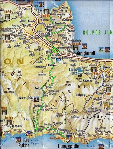
FRANGOKASTELO - SFAKIA – ASKIFOU – VAMOS – (appx. 85 km) Highlights: Starting from Frangokastelo -took its name from the beautiful fortress the Venetians built right on the beach in 1371- we continue west to Hora Sfakion (Sfakia) with the traditional houses climbed on the slopes of the White Mountains. Sfakia remain the most wild and unspoiled landscape in all Crete. In its picturesque, enclosed harbor, the small ferries travel to Loutro, Agia Roumeli, Sougia and Paleochora. Visitors can enjoy the quiet and calm of the village, on the seaside cafes and tavernas. Following the road north alongside the impressive gorge of Imbros up to the homonym village in the small plateau and then is opening up the Askifou plateau (726m altiltude). It is inhabited and cultivated since ancient times and produces excellent variety of local products which one may taste in its traditional tavernas. After Askifou descending the northern slopes of the White Mountains toward the historic capital of Apokoronas, Vamos, we can make a stop in the smothered in green by its river Vrissanos village Vrisses. From Vrisses we cross the beautiful, hilly rural landscape up to Vamos, one of the most important agrotourism centres of Crete, where dominates its traditional architecture. Starting by Vamos we can know the area of Apokoronas with the traditional villages Gavalochori, Fre, Vafe and the extraordinary nature of the valley of Armenoi with small traditional settlements.
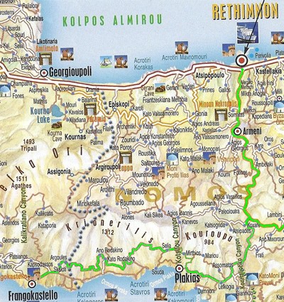
RETHYMNON COUNTY/PREFECTURE DRIVING ROUTES:
RETHYMNON – PLAKIAS – FRANGOKASTELO (appx. 80 km) Highlights: From Rethymnon following the road south to Spili we meet Mixorouma where we can admire the amazing basketry art products. Back to the junction and we follow south the road that leads us to the narrow passage of the impressive Kourtaliotiko Gorge, and after crossing it, we see one of the most beautiful areas of Crete that is the valley of Kourtalioti river and the area of seaside village Plakias. The valley Kourtalioti combines the impressive geomorphologic environment of the gorge with an ecosystem of major importance and a beach of extraordinary beauty in southern coast, where is the lake Preveli with its palm forest. At the area of Plakias, some of the most beautiful beaches of the island such as Amoudi, Schinaria, Damnoni and Souda are developed. From Plakias we climb to Selia and follow the road to the region of Sfakia until the plain where dominates in the beach the form of Frangokastelo and beside the ruins of the monastery of Agios Nikitas on the unique beach Orthi Ammos. Inside the desserted fortress of Frangokastelo the light of sunset along with the mysterious atmosphere that is created, is simply unique. Frangokastelo is connected with one of the most beautiful legends of Crete. This is a phenomenon of reflection that is happening in days of calm the 2nd half of May. The morning hours have been observed on the horizon shadows of riders. The locals have named the phenomenon “Drosoulites” i.e. “Forms of the morning freshness”.
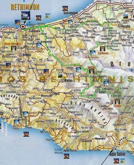
RETHYMNON – ARKADI – AMARI (appx. 120 km) Highlights: From Rethymnon following the old highway to the east, we arrive at Adele and we continue through the beautiful rural landscape dominated by traditional olive groves and small valleys with clusters of cypresses. Before Perama, we follow the road south to Margarites, a traditional village in which survives and flourishes even today the ancient tradition of ceramic art with plenty of ceramic workshops. We continue SW and arrive in the villages Prine and Eleftherna where there are the ruins of Ancient Eleftherna. We continue crossing a barren hilly landscape until the famous castle-Monastery of Arkadi, located in the centre of a small plateau with slopes overgrown from holm-oaks, oaks, pines and olives. In the elaborate façade of the church are mixed different architectural styles. The offer culmination of Arkadi is the holocaust in 9th November 1866. The pent rebels blew up the powder keg of the monastery, offering a milestone in the struggles of Crete for its freedom from the yoke of Turks. Today the monastery has been designated as a monument of Freedom, Culture and Orthodoxy. Continuing south we arrive in the beautiful valley of Amari, where except the abandoned monastery Assomaton and the archaeological site of Monastiraki, you can visit the picturesque villages Thronos (where the ruins of ancient city Sivritos), Vistagi, Amari, Merona, Ano Meros and Gerakari. We follow the road back to Rethymnon by passing the artificial lake of the dam of Potamies, and after crossing the valley until Prases, one of the most beautiful landscapes of Crete.
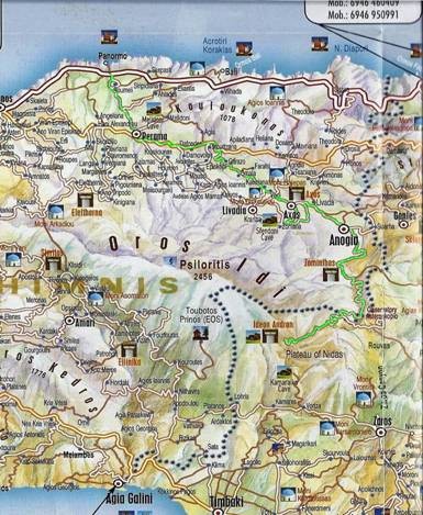
PANORMO – MILOPOTAMOS – PLATEAU NIDA (appx. 60 km) Highlights: From Panormo and after crossing the beautiful valley of Kato Milopotamos after the village Garazo, in the northern slope of the mountain, we reach the monastery Diskourios from which we follow a way that leads us to the heart of Psiloritis, with first station the village Axos.Then climb south to visit the Cave Sfentoni in Zoniana with its rich and impressive decoration. We continue to Anogia, the village with the great musical and artistic tradition. Then following the road that climbs to the south the region Zominthos, a small mountainous valley of extraordinary natural beauty that is lately transformed into a unique archaeological park, is revealed. We continue south and arrive to Petrodolakia, where we can detour for the peak of Skinakas where is the Observatory. From the peak we can admire the dry and barren, almost moonscape, landscape. Returning to Petradolakia and continuing SW, a few hundred meters afterwards reveals to us the Plateau of Nida. Here at Ideon Andron, the sacred cave of the Minoans, the greatest of the gods of ancient Greece, God Zeus, was grown according to Mythology. In the depth of Ideon Andron, one will feel that Psiloritis is indeed a source of dreams and myths.
HERAKLION COUNTY/PREFECTURE DRIVING ROUTES:
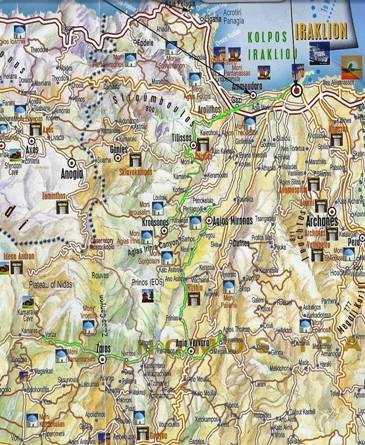
HERAKLION – KROUSONAS – ZAROS (appx. 70 km) Highlights: Starting from Heraklion we follow the National Road westwards until the junction of Gazi from where we exit in the provincial road towards Tilissos where we can visit the Minoan Villas. Following the scenic road that meanders in the hilly landscape dominated by the ancient olive groves and the famous vineyards of Malevizi, we cross the villages Moni, Keramoutsi and Korfes and we arrive in Krousonas where we can enjoy the services of agritourist infrastructures in the region and the exhibition of local products of the active Women’s Cooperative of the village. In the picturesque village of Agios Mironas with the traditional houses we can visit the church and the cavernous Skete of Agios Mironas from where it took its name. South of Asites we’ll meet the imposing rocky hill of “Patela tou Prinia” where there are the ruins of ancient Rizinia. We continue south, cross Prinia and from Agia Varvara we can visit the picturesque village Agios Thomas with many Byzantine churches and chiseled winepress. On the west of Agia Varvara, in Gergeri we can visit the exhibits of the small Museum of Natural History, the water mills and picturesque narrows of the village. We continue west to Zaros village, known from the antiquity for the source of water. South of Zaros is a large number of small abandoned villages and the artificial lake of Dam Faneromeni that has become an important biotope for the avifauna of the region. North of Zaros is the smaller but beautiful lake Votomos. West of lake we can visit the ruins of the Roman Aqueduct. West of Zaros, is the road to the historic village Vorizia.
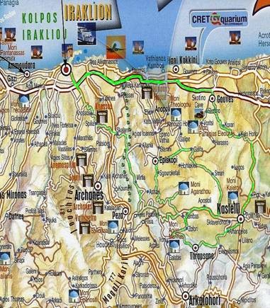
GOUVES – KASTELLI – EPISKOPI (appx. 95 km) Highlights: From Thalassokosmos –CretAquarium, located in the seaside settlement in Gournes, east of the Heraklion city, we continue south, we cross Gouves and proceed to the small village Skotino, where we can visit the worship cave of Agia Paraskevi. We continue south to Kastelli, the village that took its name from the fortress that once was dominating in the mountainous plain that was one of the largest granaries of Venetian Crete. From Kastelli we follow the road towards the south-west, we cross the small rural village Evengelismos and arrive to Thrapsano, one of the most important traditional ceramic centers of Crete, continuing the long tradition of Cretan pottery. A little northerly is Smari traditional village. East of Smari, dominates the hill on the top of which there are the ruins of the Minoan Acropolis Smari. West of Smari we will find Episkopi, a purely agricultural village with many Byzantine churches and “rakokazana” (= boilers of raki) where during the period of harvest is produced the traditional Cretan drink Raki or Tsikoudia. South of Episkopi we can visit the Monastery Agarathos, with the great lettered tradition. Following west and north the road we will reach the village Mirtia or Varvaroi from which comes the great Cretan author Nikos Kazantzakis and there is the museum of Nikos Kazantzakis, whose exhibits illumine many aspects of author’s life and work. We then cross one of the most traditional Cretan vineyards up to the village Skalani and then returning to Heraklion we will meet the archaeological site of the glorious Minoan Palace of Knossos.
CHERSONISSOS – PLATEAU OF LASSITHI (appx. 100km)
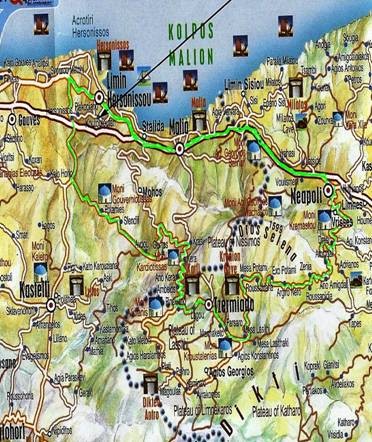
Highlights: From the junction of National Road we follow the road to Kastelli, on our right we leave the Golf Course and then we follow the road that leads east to Avdou, after crossing the beautiful valley of Potamies and bypassing the river dam of Aposelemis River. In Avdou we can visit the Byzantine churches, the cave of Agia Fotini and enjoy the services offered by the excellent local agritourist infrastructures. After Avdou we continue the uphill road that meanders in the western slopes of Dikti and get to Krasi traditional village with the beautiful fountain and then to Kera village, -which has taken its name from the Monastery of Kera with interesting Byzantine frescoes- with breathtaking view to the valley of Avdou. Above Kera dominates the peak Karfi where the ruins of one of the major Late Minoan cities are found. We continue our climb up to Ambelos village, the neck of the ridge that is the entry in the great plateau of Lassithi, with typical stone windmills. Lassithi Plateau at an altitude of 850m is the largest in Crete, the only with continuous residence throughout the year and one of the largest traditional wind farms with the characteristic type of windmill. In the slope above the village Psichro is the famous ancient worship cave Dikteon Andron, where God Zeus was born according to Mythology. Dikteon Andron consists of two main spaces, has remarkable decor and so as mythological space as a geological formation with magnificent stalagmites and stalactites is one of the most important caves of Crete. From the Tzermiado village we can visit the Trapezas cave and near the village Agios Konstantinos the Kroustalenia Monastery. We then cross the mountainous barren landscape up to the valley Potamies with the small picturesque villages and then in the village Vrisses is opened in front of us the valley of Neapoli from which we return to Malia, Chersonissos.
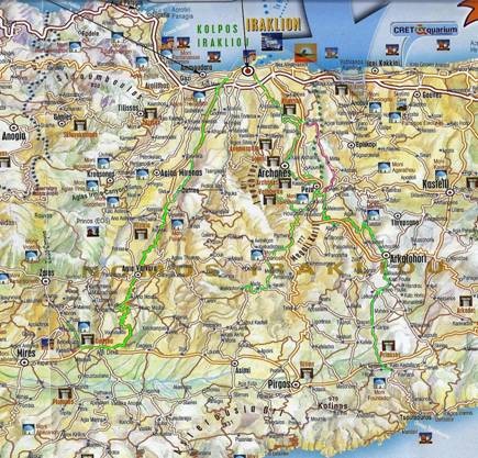
WINE ROADS: Following Knossos avenue in the southern exit of Heraklion we reach the archaeological site of Knossos. In a short distance around the Palace there are also other important Minoan monuments such as the “Royal Villa” , the Little Palace, the “Caravan Sarai” , the “House of Archpriest”, the Royal Tomb-Temple and the house of Dionysus. We then follow the beautiful valley south of Knossos and beginning to meet the first vineyards. In short distance, in Spilia, we distinguish the old bridge aqueduct carrying water to Heraklion from the sources in the region of Archanes. Then we find the intersection to the village Skalani located on the ridge of a hill covered by vines. We continue south along the road that crosses the little valley and admire a beautiful rural landscape with vineyards until the village Kato Archanes. Moving to the south we arrive at Archanes, one of the most thriving rural settlements of Greece with deep roots in the Minoan antiquity and great wine producing tradition. South of Archanes we will find the abandoned today settlement of Vathypetro, where the Minoan Palace with the ancient grape crusher, one of the most important monuments of the Minoan period, great proof of the long wine making tradition in the region. From Archanes, following the uphill road and after crossing the top of the hill east, we see the verdant of vineyards area of Kounavoi. South of Kounavoi we will meet the valley of Peza, the largest wine making centre of Crete and on the slopes of the surrounding hills spread out the traditional vine villages of the region, Agies Paraskies, Kalloni and Agios Vasilios. * If we follow the road north from Agies Paraskies we will be found in Mirtia, where operates the museum dedicated to the great Cretan author Nikos Kazantzakis.* The road south from Agies Paraskies leads us through a beautiful hilly landscape to the valley of the village Melesses and most south to Alagni where its vineyards form one of the most beautiful rural landscapes of Crete. From the region of Alagni, continuing south and after crossing an extensive rural area dominated by olive groves and less by vineyards, we arrive from Arkalohori to Kasteliana, where was the ancient town Priansos. From Peza, if we follow the road that crosses the villages Kalloni and Agios Vasilios, we will arrive in Houdetsi. In the south of the village is opened a hilly landscape with vast vineyards open to the south of the mainland of the county. Following the provincial road south of Houdetsi and after seeing the monastery Epanosifi we continue to the villages Metaxochori, Haraki, Made, Melidochori and Voria that the last years have gained a significant role in the wine production of the region.
2nd OPTION: From Heraklion city we follow the road south to Moires and after 20km appx we take the left exit to Dafnes village, a centre which maintains a long tradition of cultivation of fine wine grapes varieties and wine making and holds the famous Wine Festival which takes place during the first fifteen days of July each year with 10-15 days of duration. From the area of Dafnes we can follow the road leading south to the valley of Messara and in the region of Ancient Gortyna, the capital of Roman Crete, where in the hilly landscape of the villages Pluti and Lavyrinthos it is developed a great traditional vineyard.
LASSITHI COUNTY/PREFECTURE DRIVING ROUTES:
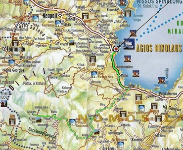
AGIOS NIKOLAOS – SELAKANO (appx. 75 km) Highlights: Starting from the picturesque Agios Nikolaos we follow the coastal road up to Istron and then we continue southwest to the hinterland with first station the small village Prina. Then, after crossing Kalamafka, with the characteristic rocky formations, we arrive in the village Males from where we can visit the Monastery of Panagia Exakousti. From Males we arrive in Christos and continue in the uphill road that leads us to the forest of Selakano. The small settlement of Selakano is spread in the pine forest of the homonym valley surrounded by the imposing slopes of Dikti. Farmers of the villages Christos and Males inhibit it mainly in the summer. The region of the basin of Selakano with the extensive pine forest is one of the most beautiful mountainous landscapes of Crete. The region has been inhabited since ancient times and in the location “Patella” there are distinct traces of ancient settlement probably the Ancient Malla. In the cafes of the village we can enjoy local cuisine in company with the simple hospitable residents.
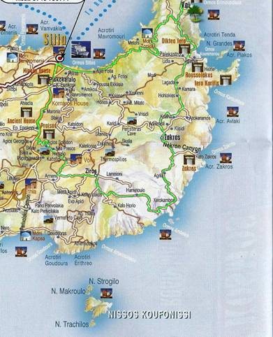
SITIA – ZIROS – ZAKROS – PALEKASTRO (appx. 110 km) Highlights: Sitia is the “Ancient Gate of the Orient” as archaeologists have named it. Today, the modern small town of Sitia with its Venetian fortress rests in the arms of the calm bay with its beautiful beach. Starting from Sitia we follow the road that leads southerly, we cross the serene scenery of the fertile valley up to Ano Episkopi, where we turn easterly and climb to meet the ruins of ancient Praisos. We continue for the village Chandras and from there we can visit Ethia with the famous Venetian villa as well as the abandoned medieval village of Voilas. From Chandras we follow the road to picturesque Ziros and then after crossing the small plateau with the ancient vineyards, we start to go down the slope with the open breathtaking view to the vast blue sea of Xerokambos with the amazing beaches where grown the lilies that are depicted in the Minoan frescoes. Continuing north we follow a route dominated by small valleys and formations of gorges with most imposing the Gorge Ton Nekron (= Gorge of Dead) that connects Pano and Kato Zakros(where the famous Minoan Palace can be visited) with the stunning pebble beach. From Pano Zakros to reach Palekastro we follow a route between a calm and peaceful landscape, hilly and ascetic with traditional rural villages. In the region of Palekastro, the landscape is flat and bright, open to the beautiful beaches of Kouremenos and Chiona, with the neighbouring ruins of the Minoan city of Palekastro. More north the visitor will enjoy the experience of the beach with the unique palm forest of Vai which occupies 200 acres and is composed of self-sown palms. Its development and maintenance is owed to the dry-hot climate and to the underground water of the valley. Following the road back to Sitia, we will feel the religious awe and the magnificence that inspires the historic Monastery of Toplou, which dominates in the deserted landscape.
